Dam in St. Petersburg: how the city on the Neva was protected from floods
St. Petersburg is not in vain called Northern Venice and the cultural capital of Russia. Unique architectural monuments, many cultural and historical sites, picturesque canals and bridges made this city extremely popular among Russian and foreign tourists. But the city built at the mouth of the Neva River during its history experienced several major floods, until, finally, an extensive system of protective dams was built, which solved this problem.
The first flood in the still under construction St. Petersburg occurred in August 1703, but in Swedish documents you can find a mention that this area was flooded earlier. In 1708, Tsar Peter I himself witnessed the flood, who wrote to A. Menshikov: "... Although the water was great, it didn’t do much trouble". But this was only the beginning, and later on the water did a lot of trouble in the city.

Over its three-century history, the city has experienced more than 300 floods of varying strength. These were mainly floods caused by the surge from the Gulf of Finland, when during a strong wind the sea waves propped up the flow of the Neva River and the water level in the river rose sharply.

The most catastrophic flood in the Northern capital occurred in November 1824, when the water rose to the level of 421 centimeters. And the worst flood of the 20th century occurred in 1924, when the water rose to the level of 380 centimeters above the level of the gauging post. Today, a flood is considered to be an increase in the water level in the Neva to the level of 160 centimeters and above, and if the level exceeds 300 centimeters, then they speak of a catastrophic flood.

All port cities of the Netherlands, London, Hamburg and many others are subject to such troubles as surge waves and the floods caused by them. The only salvation in such cases is the construction of protective dams.

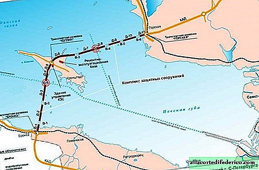
The construction of a complex of protective structures of St. Petersburg began in 1979 (the city at that time was called Leningrad). The construction was completed only in August 2011.

The complex of dams and their constituent culverts and culverts has a total length of 25.4 kilometers and is able to protect the city from flooding, leading to an increase in water level to 4.55 meters. The dam stretched across the Gulf of Finland, connecting through the island of Kotlin, on which Krondstadt is located, Sestroretsk with the station Bronka.

The complex includes 11 protective dams, which are numbered and have names from D-1 to D-11. In addition, the complex includes two culverts, C-1 and C-2, as well as six culverts, B-1-B-6.

The complex of protective structures of St. Petersburg was already involved during emergency situations and saved the city from possible floods caused by surge waves. The dam completely closed in November 2011 and in October 2013.

Watch the video: Artificial Structures on St. Petersburg Flood Barrier (April 2024).


-
The brightest photos from the festival of the dead in Mexico
While the world is preparing for Halloween and everyone is trying to come up with the most original and scary costume, another “afterlife” holiday called Day of the Dead took place in Mexico. In honor of this day, the purpose of which is to honor all the departed, the Mexicans organized an annual chilling parade. Hundreds of people turned into skeletons and walked the streets, drowning in marigolds - the main colors of Mexican funeral rites. ... -
-

-